The Digital Archaeological Atlas of the Holy Land
Pick a Drawing Tool: Show Boundaries:
Spatial Search - Digitizing Instructions
 The Spatial Search function lets you
draw an irregular area on the map and find all the sites in the atlas that fall within one kilometer of it.
The DAAHL sites are located inside the cyan rectangle shown on the map.
The Spatial Search function lets you
draw an irregular area on the map and find all the sites in the atlas that fall within one kilometer of it.
The DAAHL sites are located inside the cyan rectangle shown on the map.
There are two ways to draw on the map:
- Press the "Polygon" button to draw an area by clicking on its vertices. Each time you click the left mouse button (not holding it down to pan) the system adds
a vertex to the area of interest. The first click adds a point; the next click adds a point and draws a
line between them; the third and every later click adds a point and draws a shaded polygon. The
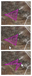
first figure above shows a minimal, three-point polygon.
In the second picture, the cursor points to a location not in the polygon. If you click the cursor in this place, the three-sided figure will be replaced by a four-sided figure, with its fourth vertex at the location of the mouse click.
Digitize points in one direction only, either a clockwise or counterclockwise, and do not try to add a point between two existing points; doing so will cause "bowtie" effects in the polygon shape, as shown in this picture.
- Or press the "Freehand Polygon" to draw a continuous polygon on the map. Move to the place you want to start drawing. Click and hold the left mouse button while drawing the area of interest. When you're finished, release the mouse button.
If you aren't satisfied with the result, press the "Clear Graphics" button to erase your drawing, then press one of the two drawing buttons again to start drawing.
Fill in the selections for the Site Point Plotting Style and KML Layer Name, then press the "Submit" button. The search polygon and its buffer are sent to the DAAHL server and a query is constructed. The results will be returned as a .kml file, which you can save and open in Google Earth or any other application that supports .kml files.
Sometimes the spatial search function can take a long time to run, depending on how large an area you drew to search. So please be patient!
The "Show Boundaries" drop down list contains four dates, 1000 BCE, 900 BCE, 850 BCE, and 700 BCE. If you select one of these dates the map will display the approximate boundaries of different political entities at the time period selected. Be aware that these are approximate boundaries only, based on archaeological and textual evidence.
The "Period" and "Component" drop down lists let you search for specific time periods and/or types of site features inside the polygon you draw on the map (and its buffer). Please note that some time periods are widely used in some places, but not others. For example, "Iron IIa," Iron IIb," and "Iron IIb/c" are not used in Israel, but they are in Jordan. In Israel, you would want to select "Iron II." This is a result of the data that was contributed to DAAHL. Sites contributed to DAAHL by the Israe Antiquities Authority do not typically pair time periods and components or site/feature types. It's only possible to do this for these sites where the site is occupied in a single period.
|
 Geo-Archaeological Information Applications Lab 979 E. Divot Drive Tempe, AZ 85283 Webmaster - shsavage@asu.edu |

|

|
|
|

|