What is the Digital Archaeological Atlas of the Holy Land?
The Digital Archaeological Atlas of the Holy Land (DAAHL) is an international project that brings together experts in information technology including Geographic Information Systems (GIS) and the archaeology of the Holy Land (modern Israel, Palestine, Jordan, southern Lebanon, Syria and the Sinai Peninsula) to create the first on-line digital atlas of the region held sacred to the three great monotheistic faiths - Judaism, Christianity and Islam. Using the power of spatial information systems such as Google Maps and Google Earth, GIS, the tens of thousands of recorded archaeological sites for the region - from the remote prehistoric periods to the early 20th century - will be entered into a comprehensive database along with site maps, photographs and artifacts. The historical and archaeological content for this project will be developed by a team of over 30 international scholars working in the region, helping to provide the data used to create the Atlas. This website and its content will serve as the prototype "knowledge node" of a more comprehensive Digital Archaeological Atlas Network for the Mediterranean region.
New developments in telecommunications and information technology are revolutionizing the fields of archaeology, history, and the social sciences. The atlas represents a signature project of the Center for the Interdisciplinary Study of Art, Architecture and Archaeology (CISA3) at the University of California, San Diego and the Geo-Archaeological Information Applications (GAIA) Lab at Arizona State University. The atlas project brings together many of these advances based on new discoveries and the latest content concerning one of the most politically complex but meaningful geographic regions in world heritage. The control of time and space allow archaeologists to uncover address the 'big questions' of human history and social evolution. These include answering how and why the major technological revolutions of history occurred and influenced social and historical change in the Middle East. In broad strokes, the control of time and space are essential commodities in the construction of a heritage-based cyberinfrastructure, which come together for scholars and the general public in the DAAHL. New developments in GIS, high-precision radiometric dating methods, and archaeological fieldwork carried out in the Holy Land (Israel, Jordan, Palestine, Lebanon, southern Syria and the Sinai Peninsula) have helped identify significant "Global Moments" of fundamental social change in this region. The atlas will harvest, analyze and disseminate settlement pattern and new archaeological data for each key period of culture change in the Holy Land, from the Lower Paleolithic over 2 million years ago to the early 20th century when the region came under British control.
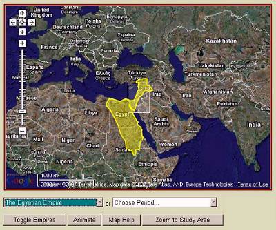
This prototype web site is organized around two central themes, a series of case studies, historic maps, and database search functions. The "Empires" theme organizes information that illustrates the march of empires across the Middle East, from the development of the first Egyptian state in about 3000 BCE to the Ottoman Empire in 1918 CE. Here, the DAAHL concentrates on the impact of imperial "ordering templates" upon the lifeways of indigenous peoples in the region, as they are reflected and refracted by imperial and local traditions. The DAAHL website incorporates an interactive Google Maps interface, which can be animated to show the spatial footprints of more than 20 empires. A drop-down list lets the user select any of the empires; a selection automatically loads text in the right side of the page that introduces the empire, and queries the DAAHL database to present the archaeological sites in the database that were contemporary with the chosen empire. (The user must be zoomed in about halfway to see the site points). Each site point can be clicked to open a balloon with its name, and the name can be clicked to open a page in the atlas that contains three groups of information: 1) the listing from the DAAHL database, showing all the filled-in fields from the site table; 2) a listing of all the chapters or case studies in the DAAHL website that discuss the project; 3) a detailed, verbal description of the site, which can be richly embedded with pictures, tables, and static maps.
How can I use the DAAHL Website?
The site now contains a variety of Google Maps interfaces that let you explore the region and the archaeological resources it contains. The link bar under the DAAHL header provides access to the main functions currently available in the website. These include:
The
Mediterranean Archaeological Network or MedArchNet is one of the first attempts to create 'Portal Science' for archaeologists and the interested public. Consequently, a major goal of MedArchNet is to make archaeological data from the Mediterranean lands accessible to various communities, including school teachers, tourists and travel agents, university students and professors, researchers, and public policy makers. MedArchNet taps into the fast-growing field of 'portal science' and will serve researchers and explorers as a platform for international collaboration, while also allowing the general public to share in the excitement of archaeology and discovery. This link takes you to the MedArchNet homepage.
Empires presents one set of examples of Global Moments in the Levant. On this page the DAAHL includes an interactive Google Maps interface that presents the rise and fall of empires in the ancient world. The map can be animated to display the empires across time; individual empires can be selected to display summary information, and archaeological sites extant during the empire's time span can be displayed and queried on the map.
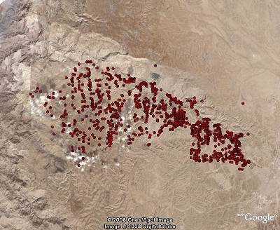
Archaeological Periods organize over 17,000 sites in the DAAHL database by more than 60 time periods from the Lower Paleolithic, more than 2 million years ago, to the Late Ottoman period, which ended in 1918. A Google Maps interface lets the user animate site clusters through time, and explore the distribution of archaeological sites in the Levant during any of these periods. Short introductions to the time periods are included as well.
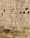
Shishak's Campaign presents information related to the Egyptian Pharoah Sheshonq I (known in the Hebrew Bible as Shishak) and his military expedition into southwestern Asia. His invasion of Judah and Israel is documented on the south wall of the Temple of Amun Ra at Karnak, and described in the Bible (1 Kings 11:40; 14:25; 2 Chronicles 12:2-9). The DAAHL uses the latest "tour" capability in the Google Earth API to track some of the movements of Shishak's army.
Case Studies are specialized, in depth explorations of different subjects in the atlas. Tom Levy's exploration of the Edomite Lowlands during the Iron Age, which is accompanied by an interactive Google Maps display, is a prime example. Other case studies are presented as online Powerpoint or HTML presentations.
About the Atlas displays information about the main research partners who are developing the atlas. The Atlas is an international project that brings together experts in information technology and Levantine archaeology to create the first on-line digital atlas of the region held sacred to the three great monotheistic faiths - Judaism, Christianity and Islam.
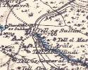
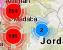
PEF Maps are maps produced for the Palestine Exploration Fund by Claude R. Conder of the British Ordanace Survey in the 1870s and 1880s. These classic maps contain more than 10,000 place names, and are an important resource for Late Ottoman period Palestine. The GAIA Lab at Arizona State University converted the map sheets into more than 50,000 tiles in an interactive Google Maps display that can be zoomed and panned to show the maps in the background, with the DAAHL archaeological sites superimposed.
Search Database opens a page in the website where users can query the database by such things as site name, time period, site type, site conditions, etc. Queries are submitted to the DAAHL web server and the results are returned to the user as dynamic kml, which opens on the user's computer in Google Earth. All sites displayed in the result sets are "backlinked" to the DAAHL database, so they can be explored indiviually by following their links. See the video below for an example of a time period search.
The
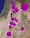
Spatial Search link opens a page with in interactive Google Maps display. The user can draw an irregular region of interest on the map and perform a search for all the sites in the DAAHL database that fall within one kilometer of the search region. Like the database search, results are displayed as points in Google Earth; the user can determine the point display style, and all search results are back-linked to the Atlas.
Use the
Make Maps function to make queries of sites by time period and/or site/feature type, and display the results on a Google Maps interactive map that includes site clusters and individual sites. Clusters can be clicked to zoom to the next level, displaying smaller clusters and individual sites. Hover over site points to see the site name. Use your computer's screen copy function to copy the map; then paste it into a graphics editing program and crop it to the map--then you can use the map in presentations or documents.
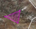
Site Preservation links to a page in the DAAHL website that displays two film clips. The first shows how the Spatial Search is done, and illustrates how this function can be used to help preserve archaeological sites by minimizing the impact of development projects through avoiding sites. The second film clip is a trailer to a movie that discusses the danger to one of Jordan's most significant Early Bronze Age sites posed by expanding gravel quarries.
Contributors to the DAAHL project have come from many countries, universities, and research institutions. All sites and project data that are contributed to the DAAHL are "branded" with the contributor's information and cross-linked to their websites. The DAAHL database safeguards our contributor's information and drives website traffic to their research projects.
Using the Digital Atlas as a Research Tool
The Digital Archaeological Atlas of the Holy Land can be used as a research tool by utilizing the "Database Search" function, which is accessed by clicking the link on the title bar at the top of the web page. The movie shown here illustrates how a database search can be done. (Note: in order to build a movie that would fit comfortably in this web page we had to greatly reduce the size of the browser window--when you run a database search, just maximize the search window to get rid of the horizontal scroll bar.)
There several ways that searches can be done, but perhaps the most useful for research purposes is a search by time period and/or site/feature type. The example movie shown here illustrates a search for all the sites in the DAAHL database from the Kebaran period. It's done by clicking the link for "Period and/or Feature" or scrolling down to that section of the page. In the Search by Period/Feature Type section you have three options:
- You can select only a time period to find all the sites from that time period, regardless of site type
- You can select only a site/feature type to find all the sites with that type, regardless of time period.
- Choose both a time period AND a feature type to find all the sites from the selected period that have that feature type -- in other words, an "AND" query.
When you have the search criteria you want, press the Submit button. The query is sent to the DAAHL server, and a list of the results is displayed. At the bottom of the listing you'll find some controls that let you pick the site symbol style, label size, and layer name. You can also choose to plot only the sites you've checked, or plot all the results. When you press one of these plot buttons, the site list is sent back to the server and formatted as dynamic .kml, which then opens on your computer in Google Earth (assuming you have Google Earth installed--the free version is sufficient).
Multiple searches can be made, and the results can be displayed with different symbols to build up a comprehensive distribution map with different layers of data, and you can copy and paste the Google Earth map into PowerPoint or Word files. If you have Google Earth Pro, you can get high-resolution images that make your projects look good!