The Digital Archaeological Atlas of the Holy Land
Spatial Search - Digitizing Instructions
 The Spatial Search function lets you
draw an irregular area on the map and find all the sites in the atlas that fall within one kilometer of it.
The Spatial Search function lets you
draw an irregular area on the map and find all the sites in the atlas that fall within one kilometer of it.
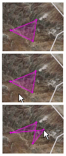
Each time you click the left mouse button (not holding it down to pan) the system adds a vertex to the area of interest. The first click adds a point; the next click adds a point and draws a line between them; the third and every later click adds a point and draws a shaded magenta polygon. The first figure above shows a minimal, three-point polygon.
In the second picture, the cursor points to a location not in the polygon. If you click the cursor in this place, the three-sided figure will be replaced by a four-sided figure, with its fourth vertex at the location of the mouse click.
Digitize points in one direction only, either a clockwise or counterclockwise, and do not try to add a point between two existing points; doing so will cause "bowtie" effects in the polygon shape, as shown in this picture.
If you need to change the location of a point you've already entered, just click and drag it to a new location. If you want to delete a point, simply click it. If you want to remove the entire polygon and start over press the "Reset Map" button. When you are satisfied with the shape of your Area of Interest, press the "Submit Search" button.
The map will not allow searches outside the DAAHL study area, which is marked by the white rectangle. An error message will be shown if any point you digitize is outside the rectangle.
When the map is zoomed in closely sites are shown as red dots. Hover the cursor over a site point to see its name. You can click them to open an information balloon; clicking the site name in the balloon opens its information page in a new window.
|
 Geo-Archaeological Information Applications Lab 979 E. Divot Drive Tempe, AZ 85283 Webmaster - shsavage@asu.edu |

|

|
|
|

|